

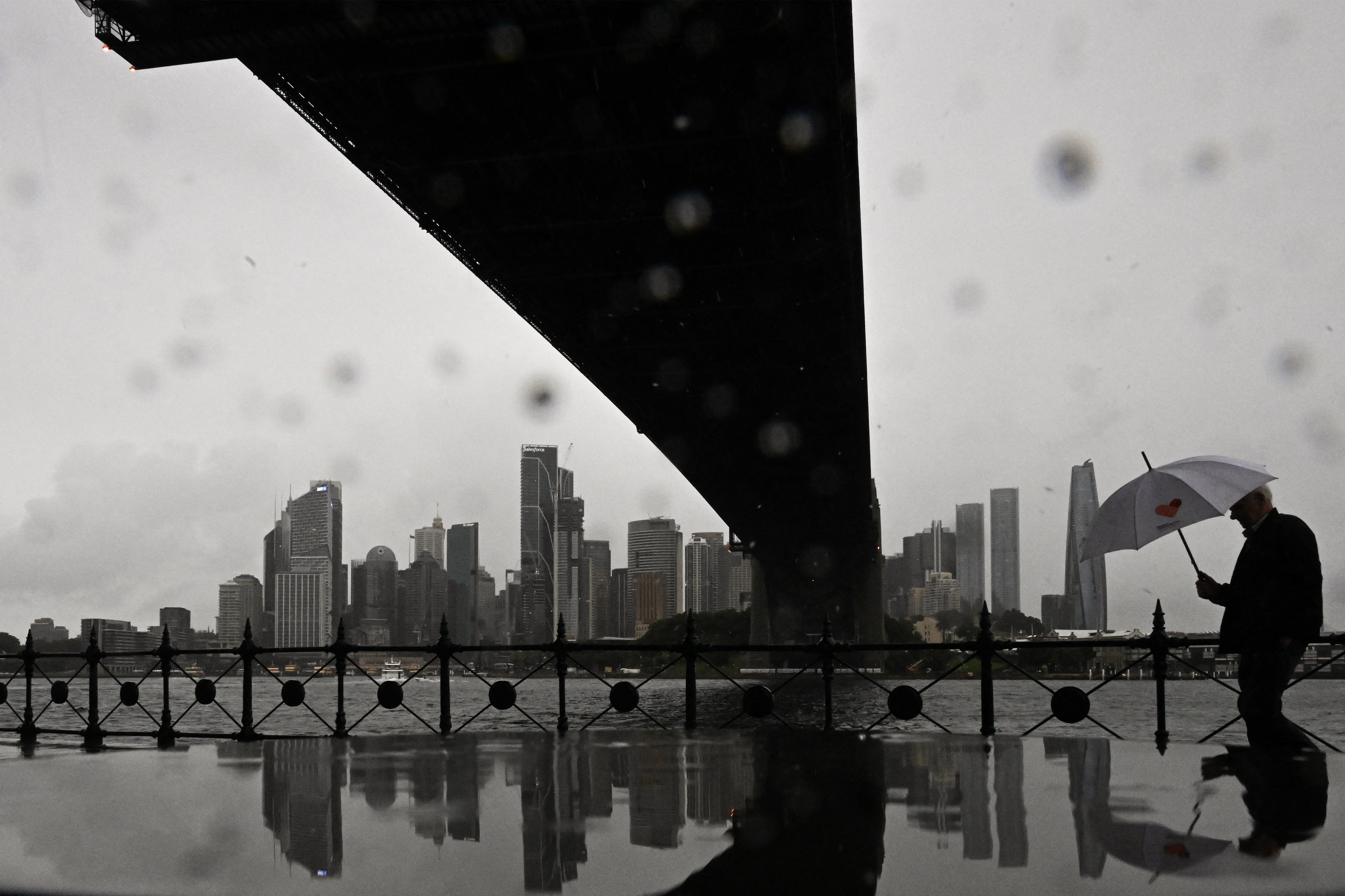
A rapidly intensifying low-pressure system known as a “bomb cyclone” is lashing Australia’s east coast with heavy rain and winds, prompting evacuation orders for coastal properties.
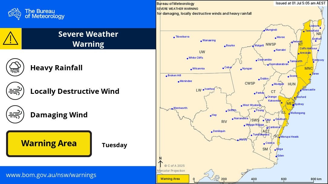
Authorities on Tuesday warned that parts of New South Wales could expect the weather to worsen in the next 24 hours, with up to 250mm (9.8 inches) of rain and winds up to 125kmph (78mph) predicted.
Emergency services minister Jihad Dib said the size of the system was "enormous".
"It may seem pretty bad but the terrible thing is the situation is going to worsen over the course of the next 24 hours," he told a news conference on Tuesday afternoon.
Residents living in areas vulnerable to coastal erosion have been told to leave their homes, with minor flood warnings also in place for several communities along the state's Mid North Coast. Authorities received over 900 emergency calls on Tuesday.
Several domestic flights from Sydney airport including from operators like Qantas and Virgin airlines were cancelled.
Ferries and trains suspended as storm causes major transport chaos in NSW
Severe storms battering New South Wales have forced the suspension of several ferry and train services, stranding commuters and delaying travel across the state. Train services on the Central Coast line between Fassifern and Wyong have been suspended after a tree fell on overhead powerlines at Dora Creek. Further south, services were delayed earlier in the day when a tree came down near Kiama.
Ferry services have also been hit hard. The F1 route is suspended except for an hourly Manly service, while F9 Watsons Bay Wharf is closed due to dangerous winds, halting ferries between Rose Bay and Watsons Bay.
Speaking to ABC’s Afternoon Briefing, transport for NSW coordinator general Howard Collins warned: “We are anticipating quite a tough night on public transport and the roads are very slow.”
He added: “The combination of strong winds and heavy rain means not only flooding, but trees and other things. We’ve just seen the roof of a restaurant blow away just near Gosford… If you are planning to get home, leave early. Take your time. Don’t leave it till late in the evening because that’s when disruptions occur.”
Stuti Mishra1 July 2025 11:45
Mapped: Areas under rainfall and wind warning
Stuti Mishra1 July 2025 11:27
Fallen trees spark car crashes on NSW coast
Emergency services in New South Wales are warning of worsening conditions as powerful winds and torrential rain bring down trees and powerlines across parts of the Central Coast and Sydney.
NSW SES deputy commissioner Debbie Platz told ABC News: “We will see conditions deteriorate even further overnight for Sydney, the Illawarra and South Coast areas.”
Ms Platz said emergency crews were already overwhelmed: “What we’re seeing already are trees and powerlines coming down in some parts of the Central Coast and Sydney. And we have at the moment over 1,200 amazing volunteers and our emergency services partners who are responding at the moment to well over 1,000 jobs.”
She added that around 9,000 customers on the Central Coast were without power as of Tuesday evening, and dangerous road conditions were leading to serious accidents.
“In one instance, for example, there’s a tree that came down in the Lake Macquarie area and that caused a four-car accident. So it’s very dangerous conditions out along the east coast of New South Wales,” she warned.
Stuti Mishra1 July 2025 11:10
Tens of thousands without power as storm lashes NSW coast
Tens of thousands of homes and businesses have lost power across New South Wales as powerful winds and torrential rain hammer the state’s east coast.
Ausgrid, which services Sydney, the Central Coast and the Hunter region, confirmed this afternoon that around 18,000 customers were without power as of 4pm, with strong winds and heavy rain bringing down powerlines across its network.
By 5pm, Ausgrid’s website showed 54 unplanned outages affecting 26,797 sites across the Hunter, Central Coast and Sydney coastline.
In a statement, the company said: “Ausgrid crews, including emergency teams, are working around the clock to restore power safely and as quickly as possible. We’re asking everyone to take extra care, especially around fallen trees and storm debris, which may be hiding hazards. If you see fallen powerlines, always assume they are live.”
The NSW SES said the Central Coast is starting to “feel the impacts of the coastal low, with rising incidents and reports of power outages.” Authorities urged people to stay indoors if safe, avoid unnecessary travel, and never drive through floodwater.
Stuti Mishra1 July 2025 10:55
What is a bomb cyclone - and why the NSW storm may not be one
The powerful weather system lashing New South Wales has been widely described by experts and the media as a “bomb cyclone” because of how quickly it intensified off Australia’s east coast.
A bomb cyclone, or “bombogenesis”, refers to a low-pressure system that deepens rapidly - its central pressure dropping by at least 24 millibars in 24 hours - creating a storm capable of unleashing extreme rain, destructive winds and dangerous coastal conditions.
Several meteorologists have said the current storm has many features of a bomb cyclone, including rapid strengthening and severe impacts. However, Australia’s Bureau of Meteorology has described it as a “vigorous coastal low”, noting it doesn’t meet the criteria for an official east coast low.
Regardless of terminology, authorities are warning of life-threatening conditions across coastal communities, with evacuations underway, widespread power outages and more heavy rain and damaging winds expected into Thursday.
Stuti Mishra1 July 2025 10:41
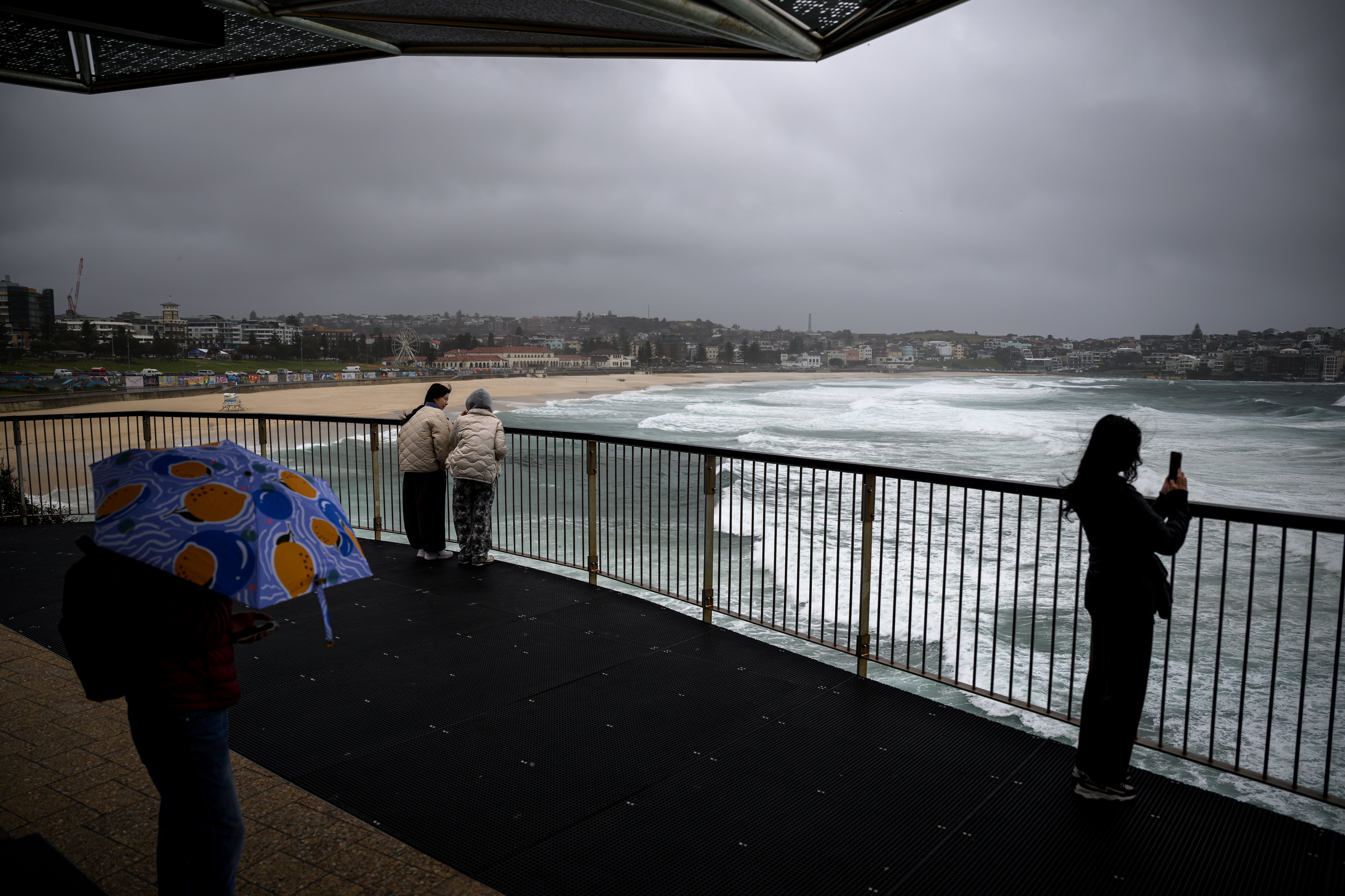
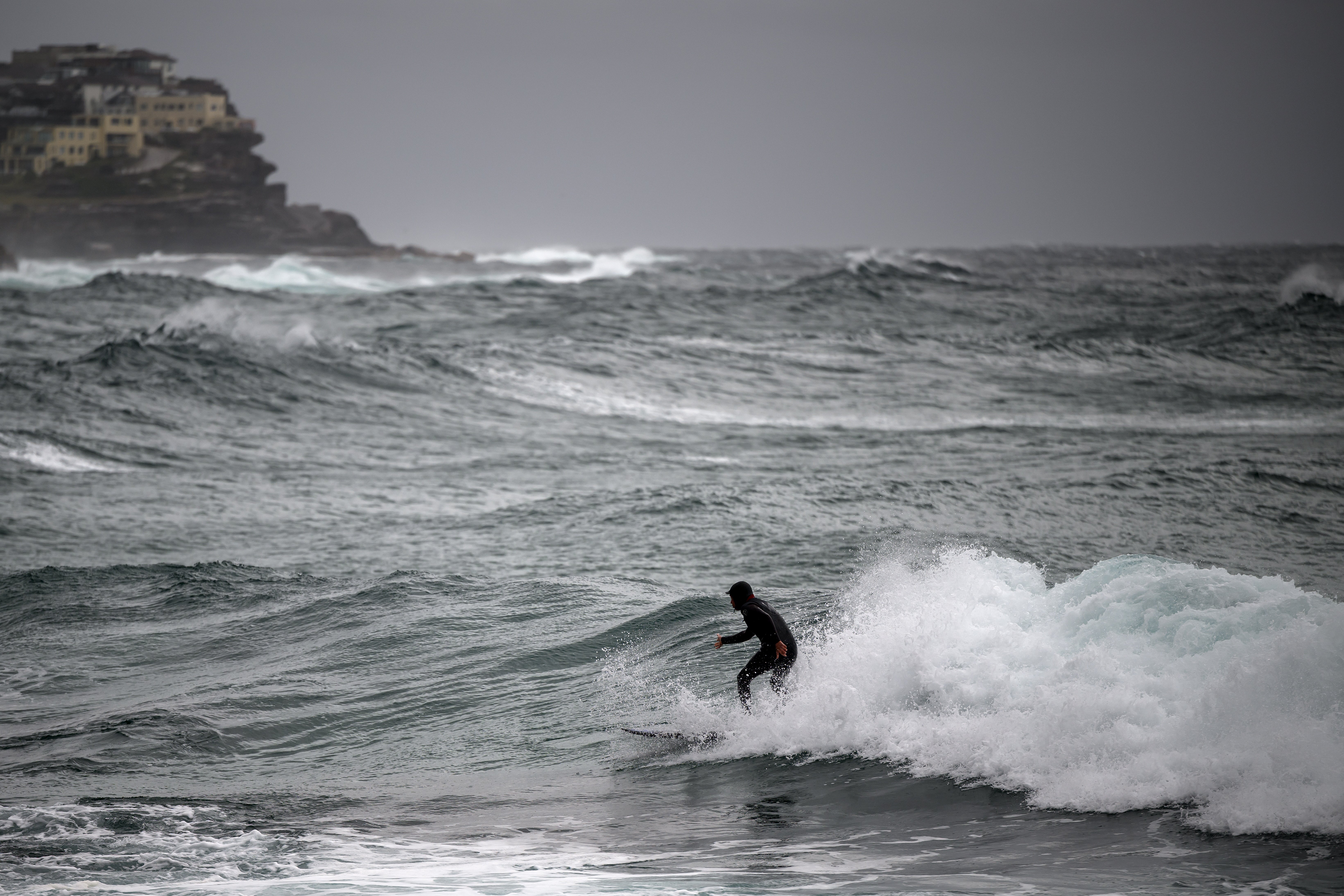
Photos: Large swells seen at beaches
Stuti Mishra1 July 2025 10:22
Severe weather to persist tomorrow, easing by Friday, forecasters say
The Bureau of Meteorology says dangerous conditions from the powerful east coast storm will continue through Wednesday, with warnings for damaging winds and large seas still in place.
“Damaging winds and large seas will continue across much of the coast through Wednesday, with warnings expected to continue," senior meteorologist Helen Reid said.
The bureau expects the system to gradually move offshore into the Tasman Sea on Wednesday, with conditions improving later in the week.
“Conditions will continue to ease into Friday with only very light isolated showers lingering about the east coast by the end of the week,” Ms Reid added.
Stuti Mishra1 July 2025 10:07
Flights cancelled as storm disrupts Sydney Airport
Severe weather from the powerful “bomb cyclone” lashing Australia’s east coast has forced airlines to cancel dozens of flights out of Sydney Airport.
Qantas has cancelled at least 11 domestic services, while Virgin Australia has grounded 12 flights, according to the airport’s latest updates.
A spokesperson for Virgin Australia said: “Some services on Virgin Australia's network have been impacted by adverse weather in Sydney and Newcastle today.”
While domestic flights have borne the brunt of disruptions, no international flights have been affected so far. Passengers are being urged to check directly with airlines for the latest updates, as conditions are expected to remain hazardous through Wednesday.
Stuti Mishra1 July 2025 09:57
'Sheer size' of system is 'enormous', minister says
NSW Minister for Emergency Services Jihad Dib said the worst was to come over the next 24 hours.
“It may seem pretty bad but the terrible thing is the situation is going to worsen over the course of the next 24 hours, particularly later this afternoon and into the evening tomorrow,” he told reporters.
“We are asking people to be as prepared as they possibly can be. That system stretches as far from the Mid North Coast down to potentially Bega on the South Coast. Just the sheer size of it is quite enormous.”
Stuti Mishra1 July 2025 09:50
Emergency evacuations underway on Central Coast as storm batters coastline
Residents in waterfront areas of Wamberal and The Entrance, north of Sydney, are being evacuated as massive waves and severe coastal erosion threaten homes.
Authorities have issued emergency warnings directing people to leave immediately, warning that dangerous surf is already causing significant damage to beachfront properties.
Emergency services crews have been going door-to-door to alert residents and assist with evacuations.
Officials say a high tide later tonight could worsen erosion, raising the risk of homes collapsing along the coastline.
"We've got a high tide coming in later this evening, in addition, you throw in a bit of the rain and it might not be worth taking the risk [to stay]," emergency services minister Jihad Dib said.
Locals are being urged to stay away from beaches, secure belongings, and follow evacuation routes as advised.
Stuti Mishra1 July 2025 09:34