1 hour ago
4
1 hour ago
4

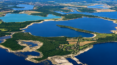
In eastern Germany, enormous pits carved into the landscape by decades of lignite mining are being transformed into a vast network of lakes, wetlands and restored land. The Lusatian Lakeland, spread across Brandenburg and Saxony between Berlin and Dresden, is being created by flooding former open-cast mines and reshaping their surroundings.
The tourist destination now comprises 23 post-mining lakes covering about 14,000 hectares of water. The transformation began with Lake Senftenberg in 1967 and has continued for decades, turning one of Germany's major coal-producing regions into a new water landscape. The project combines environmental restoration with tourism, recreation and long-term rehabilitation of land heavily altered by mining.
Germany transforms coal pits to a giant lake landscape
Lusatia was one of Germany's major lignite-mining regions, and open-cast extraction left huge excavated areas after the coal was removed.
The first major step towards their transformation began in 1967, when the former Niemtsch open-cast mine started filling to create Lake Senftenberg. Flooding was completed in 1972, and the lake opened for public use the following year. Since then, numerous other mine pits have been flooded, creating what regional authorities describe as Europe's largest artificial water landscape.
The process has involved both groundwater and water brought in from rivers and other sources.
According to mining-rehabilitation company LMBV, the rapid flooding of some mine voids was necessary because the enormous quantities of material removed during mining left large depressions that could not simply be restored to their original form.
A network of 23 post-mining lakes
The Lusatian Lakeland is not a single giant lake but a collection of former mining sites that are gradually being integrated into a connected water landscape. LMBV identifies 23 post-mining lakes within the tourist destination, with a combined water surface of around 14,000 hectares.
Five of the most prominent are Senftenberger See, Geierswalder See, Partwitzer See, Sedlitzer See and Großräschener See. Their transformation has taken place over different periods, with Senftenberger See being the oldest of the group and Sedlitzer See among the most recent to reach its target level.
In 2025, Sedlitzer See reached its planned water level, marking a major stage in the creation of the lake network.
At about 1,400 hectares, it has become the largest recreational lake in the Lusatian region.
Five lakes now form a connected waterway
The transformation is extending beyond the creation of individual lakes. Canals are being constructed to connect several of the former mining pits, allowing boats to move between lakes that were once separated by mining infrastructure and spoil heaps. On June 29, 2026, five major lakes were officially connected through navigable waterways, creating a continuous water area of roughly 5,100 hectares.
The network includes Senftenberger See, Geierswalder See, Partwitzer See, Sedlitzer See and Großräschener See.
LMBV says the wider plan involves 13 navigable canals, of which four have been completed, while others are under construction or in planning. The new connections are intended to support boating and passenger shipping while creating a unified tourism destination from landscapes that were once dominated by mining.
Nature is returning around the former mines
The creation of lakes is only one part of the region's environmental transformation. Mining rehabilitation has also involved stabilising former mine slopes, restoring land and allowing new vegetation to establish across areas that were previously heavily disturbed. Young forests are growing on former spoil heaps, while grasslands, wetlands and other habitats are emerging around the newly created water bodies.
The changing landscape is therefore not simply an exercise in filling holes with water, but a long-term effort to establish a functioning post-mining environment. The scale of the intervention is considerable: LMBV says about 15,000 hectares of water surface has already emerged in the Lusatian Lakeland, while additional post-mining lakes continue to be developed elsewhere in Germany's former mining regions.
A new future for a former coal region
The lakes are also changing the economic identity of Lusatia. Beaches, marinas, cycling routes, campsites and water-sports facilities are being developed alongside the restored landscape, while parts of the region's industrial history remain visible through mining heritage sites and visitor attractions. The transformation is particularly significant because it is taking place in an area whose landscape and economy were shaped for generations by lignite extraction.
The result is a new regional identity built around water, recreation and nature while retaining links to the industrial past. Regional authorities describe the Lusatian Lakeland as Germany's fourth-largest lake district and Europe's largest artificial water landscape. What began with the flooding of a single former mine in 1967 has consequently grown into a decades-long landscape transformation involving two dozen lakes, interconnected waterways and thousands of hectares of reclaimed land.