23 minutes ago
4
23 minutes ago
4

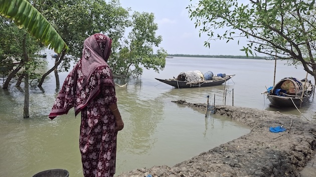 Nurunnahar, 45, is always afraid of the tide. Early warning of the tide helps her prepare. Photographed at Jhapali village in Shyamnagar upazila (sub-district) of Satkhira district, Bangladesh. Credit: Rafiqul Islam Montu/IPS
SHYAMNAGAR (Satkhira), Bangladesh, October 1 (IPS) - Villagers rush to the vulnerable spot of the embankment—early warning of the rising tide has alerted them. Together, they save the village from tidal flooding by repairing the vulnerable embankment, which is at risk from the impact of low pressure in July this year. The message is clear: early warnings of the rising tide save lives and property.
This wasn’t always the case. Cyclone Amphan in 2020 and Cyclone Yaas in 2021 destroyed the embankment in question, which is located in Datinakhali village, Burigoalini Union, Shyamnagar sub-district, Satkhira district, southwestern Bangladesh. But there was no early warning of the rising tide at that time, and the cyclone caused extensive damage.
Every year during the monsoon, the pressure of tidal water in various parts of the Bangladeshi coast breaks or overflows the embankment. This causes extensive damage to homes, resources, and crops. Many displaced families have been forced to move elsewhere after facing severe losses.
“Real-time area-based tidal surge warnings are helping us in disaster preparedness, saving resources and lives. We can take necessary measures to protect ourselves before the tidal surge. But we have faced losses again and again because we did not have this opportunity before,” explained Meherun Nesa, 45, a resident of Kalbari village in the Shyamnagar sub-district of Satkhira district. Rokeya Begum, 40, Sakina Begum, 39, and many others shared the same opinion.
The United Nations has set the goal of Early Warning for All by 2027 to save people from disasters. On the other hand, a new UN report published on August 31, 2026, says that more than 14 million people in the South Asian delta region are at risk of losing their shelter due to rising sea levels.
Their homes will be permanently submerged. Bangladesh is one of the countries at risk. It is crucial that updated disaster warnings reach people like Meherun Nesha, who live in disaster-prone areas of the country.
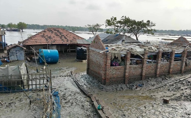 This house in Anuliya village in Asashuni upazila (sub-district) of the Satkhira district, Bangladesh, was swept away by tidal water pressure in April 2025, before there was a cyclone warning system. Credit: Rafiqul Islam Montu/IPS
Early Warnings Protect Against Tides
Early warnings were given in 25 places during low sea levels in July, August, and September this year about the risk of breaking embankments or overflowing embankments. After receiving the warnings, villagers repaired the embankments in the two most vulnerable places.
In other places, villagers have also carried out additional preparatory work. Now, people living on the coast can know in advance whether the tide will rise or whether the embankments will collapse under the pressure of the tide. By getting warnings, they are able to prepare themselves and save resources.
Artificial Intelligence (AI)-based scientific early warnings are also protecting the coastal people of Bangladesh from major disasters like tidal waves and embankment collapses. This technology is capable of providing accurate forecasts three days in advance of the cyclone.
The technology provides advance information about the location of potential tidal waves, water height, flooded areas, and vulnerable embankments. Through these capabilities, meteorologists and disaster management professionals can make quick decisions. Disaster management professionals hope that the technology will further enhance Bangladesh’s capacity to deal with disasters and will play an effective role in reducing losses.
The country currently provides cyclone forecasts, but being port-based or large area-based, these forecasts do not cover specific areas. These forecasts can’t accurately identify the specific location of tidal waves, potential water height, or flooded areas. To overcome this limitation, a scientific model has been developed with international cooperation, which is known as ‘Surf IT.’
The international organization Action Against Hunger and North South University are working jointly under the leadership of Bangladeshi non-governmental organization Uttaran to combat the disaster. Technical assistance is provided by the Bangladesh Meteorological Department (BMD), Flood Forecasting and Warning Center (FFWC), Water Development Board (BWDB), and Department of Disaster Management (DDM). The International Development Research Center (IDRC) provides financial support for the project.
How Does ‘Surf IT’ Work?
The model works by combining tides, temperature, and wind speed. It is combined with local knowledge. It involves marginalized communities in the project area. The model has been developed following the experience of weather forecasting systems in the European Union and the United States.
It not only measures the height of the tidal wave but also analyzes the condition of coastal embankments, their load-bearing capacity, and where the embankments are at risk of failure, and creates a map of flooded areas. Water sensors are constantly monitoring the river system and quickly detect any changes in water levels. Dams have been mapped to identify vulnerable areas and potential breach sites.
A digital dashboard has been created to convert complex data into simple and effective warnings. These help in providing forecasts. The information is sent to marginalized communities in local languages. It is sometimes sent via voice calls and sometimes via text messages. It is sent in such a simple language that anybody can access the message from any mobile phone.
According to the researchers, the latest test has shown that the model’s predictions are about 98 percent accurate. Work is underway to make it 100 percent accurate. Therefore, the model was tested at the field level in June, July, August, and September this year.
The project plans to transfer the technology to the government for use in the national disaster forecasting system. Currently, the project covers about 500,000 people in 20 unions across 3 sub-districts in 2 districts in southwest Bangladesh. The sub-districts are Shyamnagar, Asashuni in Satkhira district, and Koyra in Khulna district.
Will Reduce Loss and Damage
Md Jakariya, head of the ‘Surf IT’ technical team and professor in the Department of Environmental Science & Management at North South University, said, “One of the goals of the project is to reduce damage not only from major cyclones but also from regular very high tides and small tidal waves. Usually, even in the absence of major government assistance, people in coastal villages suffer a lot. The project has been initiated to reduce that damage.”
Discussions with the government are ongoing.
“This modern model is now final. Regular policy-making meetings are being held with high-level government officials to increase its effectiveness. The model is capable of predicting disasters three days in advance,” Zahid Amin Shaswat, Head of Program at the NGO Uttaran, which implements ‘Surf IT,’ said.
The advantage of this technology is that it goes beyond forecasting.
“Cyclone forecasting alone is not enough in coastal risk management; accurate information about the location, height, and potential flood areas is the most important thing in protecting human lives and property. Therefore, if such a technology based on scientific information can be effectively implemented, early evacuation of people to safe places, dam protection, and decision-making by local administration will be more realistic,” Environmentalist Sharif Jamil said.
Bangladesh in the Face of Disasters
Disasters like cyclones, floods, and heat waves are increasing in Bangladesh. Recently, coastal marginalized communities are facing loss and damage due to the impact of high tides.
In the latest long-term Global Climate Risk Index (CRI) published by Germanwatch, Bangladesh ranks 13th among the most vulnerable countries in the world. The World Bank has expressed concern that 216 million people will be internally displaced in six regions of the world by 2050 if necessary measures are not taken to prevent climate change. Of these, 40 million people will be displaced in South Asia. In South Asia alone, 19.9 million people are expected to be displaced in Bangladesh.
A recent joint study by the Internal Displacement Monitoring Centre (IDMC) and the Refugee and Migratory Movements Research Unit (RMMRU) says that more than 21 million people were displaced due to cyclones, floods, and tidal waves in Bangladesh between 2008 and 2025.
Meanwhile, in July this year, Disaster Management and Relief Minister Asadul Habib Dulu informed the National Parliament that floods and cyclones have caused Tk 41,200 crore (about US$ 3.3 million) in damage in the country over the five years from 2021 to 2025.
“In addition to major disasters, disasters like sudden high tides cause extensive damage to rural villages. Here, technology is being combined with the long-standing experience and folk knowledge of local people. Through this approach, it is possible to predict more accurately which dams are weak, where the risk of collapse is high, and where water can overflow,” added Md Jakariya.
Experts involved in the project hope that accurate early warning will ensure the safety of coastal people and reduce the risk of cyclones and tidal waves due to climate change. At the same time, the project will further strengthen Bangladesh’s capacity in disaster management.
On the ground people from marginalized communities, like Meherun Nesa, find hope in this message from experts.
IPS UN Bureau Report



© Inter Press Service (20261001131204) — All Rights Reserved. Original source: Inter Press Service