1 hour ago
2
1 hour ago
2

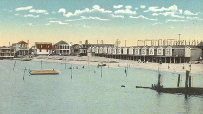
Photos courtesy NPS/Gateway NRA
A collection of vintage postcards donated to the National Park Service has given historians a detailed look at life along the New Jersey coast in the early 20th century.In a series of oral history interviews conducted by National Park Service historians Tom Hoffman and Elaine Harmon, retired Lieutenant Colonel John Joseph Patrick Mulhern examined items from the Paul Koeptchem postcard collection.
He shared memories of living and working on the Sandy Hook peninsula between 1908 and 1927.The collection contains 24 colour postcards, catalogued as series number 272 at the Sandy Hook museum. It entered the National Park Service archives in November 1975 after Emily Tepia, the executor of Koeptchem’s estate, donated it. Koeptchem lived in Highland Beach from 1907 until 1962.The interview transcript, published by the National Park Service as part of the Gateway National Recreation Area’s historical records, shows how coastal communities and maritime stations operated before modern navigation technology and large-scale development.
Early ship tracking and radio experiments
While looking at a postcard showing the Twin Lights of Navesink, Mulhern explained how ships were tracked along the New Jersey coast before electronic tracking systems existed.According to his account, marine observers working for commercial telecommunications companies watched ships heading toward New York Harbor from towers along the coast.“All these men, marine observers kept 3 x 5 cards on which they had manually prepared the silhouettes of all known vessels that would come in and out of New York Harbor,” Mulhern said in the interview.
The observers could identify ships by features such as the number of smokestacks, masts, and the overall shape of the vessel. They also knew when certain ships were expected and could report their movements as they passed specific points on the way into New York Harbor.Mulhern also remembered his own connection to early radio technology. In 1919, he and Earl Lucas, the son of Twin Lights keeper Earl Lucas, obtained amateur radio licences together.Lucas placed an antenna between the lighthouse’s north and south towers. This helped launch a long career in radio engineering, eventually leading to his position as chief engineer at station WPAT.Mulhern also identified landmarks in the postcard images, including the anchors of an early Marconi wireless tower just north of the north lighthouse. The anchors were still visible in the ground decades later.
How the Navesink lighthouses worked
The oral history also explains how the Twin Lights operated in the early 1900s.Although the site had two towers, Mulhern said only the south tower normally operated as a navigation light.“The lighthouses, as long as I can remember there was only one operational light and that was the one at the south end of this structure,” he said in the National Park Service transcript.The south light used a revolving double convex lens. A clock-like mechanical system turned the heavy glass lens.The system was powered by a large weight that slowly dropped and had to be manually wound back up once or more each day.
The mechanism powered both the clockwork and the rotating lens.To people standing close to the lighthouse on land, the light appeared steady. But sailors about 15 miles offshore saw a fast flashing light as the lens turned.The north tower used a fixed light. It mainly served as a backup when the main south light was being repaired or maintained.Mulhern also recalled that visitors could enter the lighthouse only when the keeper allowed them to.
It was not operated as a public park at the time.Later, federal officials added notes to nautical charts identifying the light as privately maintained. This helped protect shipowners from making claims against state authorities if a vessel ran aground, especially as newer technologies such as Loran and radar replaced traditional lighthouse navigation.
Changes to the landscape and ice harvesting
While reviewing postcards of the Highland Beach resort, which was operated by the Sandlass family from 1893 to 1962, Mulhern pointed out changes to the peninsula’s landscape and buildings.The postcards show open fields, empty lots, and freshwater ponds that have since been replaced by homes and paved roads. During Mulhern’s childhood, these natural areas were important parts of everyday life.“In fact, some of them are built right on top of the spot where there used to be ponds where we used to go ice skating in the wintertime,” Mulhern recalled in the National Park Service record.He also explained that ice was cut from the ponds during winter and sold to nearby homes or stored in icehouses.Mulhern remembered how transportation changed across the peninsula. Before permanent roads were built, people travelled over the sandy ground using wooden trestles and gravel roads.Before modern highways, flatcars and horse-drawn wagons travelled beneath railway trestles near the Sandlass Bathing House. The area’s first single-lane concrete road was built around 1916 or 1917 during the First World War period.The postcard collection and oral history transcripts remain part of the permanent historical reference library at Gateway National Recreation Area. Together, they provide valuable primary-source evidence about the region’s maritime activities, technology, communities, and changing landscape.