 4 months ago
40
4 months ago
40

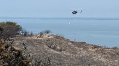
OPINION — America is entering a future with millions of drones in our airspace. As the federal government works to determine how to manage what will become the most crowded skies in human history, we believe state and local governments will face significant challenges in addressing this issue, regardless of what federal authorities ultimately establish. As with most public safety incidents, the first response to drone-related events—crashes, unsafe or suspicious flights, interference with emergency operations, or calls from concerned citizens—will fall to state and local first responders.
We are both investors who have managed portfolios of UAS (Unmanned Aircraft Systems) and C-UAS (Counter-Unmanned Aircraft Systems) companies. What’s top of mind for us as we consider the challenges and opportunities this new market presents? Here are five quick thoughts from conversations we had over coffee this past weekend.
1. The Growing Gap Between Drone Proliferation and Local Airspace Awareness
The FAA estimates nearly 2 million drones could be operating in U.S. airspace within the next few years—yet the United States has no broadly available, affordable solution for comprehensive low-altitude airspace monitoring accessible to state and local governments.
Federal efforts to address this are underway. The FAA’s proposed Part 108 regulations, expected to be finalized this year, attempt to address this gap through Unmanned Traffic Management (UTM) systems and Automatic Dependent Surveillance Broadcasts (ADS-B). But existing detection capabilities remain fragmented: there is no widely adopted, comprehensive, real-time network capable of tracking drones over most of the country. Unlike traditional air traffic control, smaller low-altitude drone operations lack the management infrastructure required for safe, high-density operations. And critically, it is also worth noting that while federal regulatory frameworks may succeed in shaping the behavior of cooperative, law-abiding operators, bad actors are under no obligation to comply.
The gap is felt most acutely at the local level. For a small-town police department, limited authority, limited airspace awareness, and limited counter-drone capabilities often mean that the most law enforcement can do when a drone is operating where it shouldn't is attempt to locate the pilot and ask them to land.
The technology to do more does exist—RF sensors, acoustic systems, radar, and EO/IR cameras are all available—but deploying them at scale demands personnel, training, maintenance, and infrastructure integration. Even so-called "affordable" systems carry substantial operational burdens. For many local governments facing constrained budgets and competing priorities, procuring and sustaining such systems is simply out of reach.
We believe there is a clear and largely unmet need for affordable, scalable airspace awareness and management platforms that can be deployed for safety, security, operational visibility, and situational awareness.
2. Legal and Resource Barriers Facing Local Drone Enforcement
Local governments face significant limitations in enforcing drone regulations—and the scale of the problem is likely underestimated. For instance, hundreds of drone incursions over correctional facilities are publicly reported each year, yet most go uncontested, suggesting the true volume may be orders of magnitude higher when accounting for incidents that go unnoticed or unreported.
Most agencies simply lack the funding, trained personnel, and technical infrastructure needed to respond meaningfully to drone threats at high-risk sites. A patchwork of state-level regulations further complicates enforcement. Several states require search warrants for drone surveillance, while other aspects of drone law vary widely across jurisdictions. Costs compound these challenges—detection systems range from roughly $10,000 for basic equipment to several million dollars for advanced tracking and jamming capabilities, a spectrum that puts even entry-level solutions out of reach for many municipalities.
These converging legal, operational, and financial constraints point to a clear and underserved market across several opportunity areas we see as compelling: Counter-UAS as a Service, training and certification programs, contracted subject matter experts, automated CUAS monitoring platforms, and more. Each model offers a distinct way to address the capability gaps facing local agencies.
3. The Growing Divide Between Federal Authority and Local Capability
While state and local authorities remain resource-limited, the federal government is moving quickly to expand counter-drone authorities—highlighting what we see as a growing imbalance.
Earlier this year, the U.S. Department of War announced updated homeland counter-UAS guidance through its Joint Inter-Agency Task Force 401 (JIATF-401). The guidance expands installation commanders’ authority under 10 U.S. Code §130i, removes prior “fence-line” limitations, and treats unauthorized drone surveillance as a threat before an aircraft crosses a perimeter. Commanders are now empowered to act based on the totality of circumstances, share sensor and tracking data across DHS and DOJ, and employ trained contractor personnel to operate counter-UAS systems.
This shift reflects an important reality: the federal government is acknowledging that low-cost, weaponizable drones are already being used and that waiting for a physical breach is no longer acceptable. At the same time, this expanded authority introduces an additional concern—counter-drone operations may now occur over populated areas.
But this progress also underscores the widening gap between federal and local capabilities. While military installations gain expanded authorities, local authorities remain restricted in their ability to intercept or mitigate drones.
4. The 250-Gram Decision Hiding Millions of Drones from FAA Oversight
In an attempt to manage and regulate the rise of drones, the FAA requires all commercial drones and any recreational drones over 250 grams to be registered with them for the purposes of accountability, operator identification, and to support regulatory compliance and law enforcement. Drones at or above this threshold must also be marked with a unique identifier and—under the FAA’s Remote ID rule—broadcast their location and identity in real time during flight. Sub-250g drones escape all of these requirements entirely, meaning there is no reliable way to know how many small drones exist or operate in the U.S. today.
This exemption has created a significant blind spot. Manufacturers intentionally design capable, camera-equipped drones to weigh just under the 250-gram threshold—and it’s not difficult to imagine the many ways a bad actor could exploit these unregistered small drones, whether deployed individually or as part of a larger fleet.
The scale of the problem should not be underestimated. The gap between registered drones and actual ownership suggests the unregistered population may be three to five times larger than the registered fleet—meaning a significant number of sub-250g drones are operating in U.S. airspace today, effectively invisible to FAA tracking systems and other oversight mechanisms. We see this as one of the most urgent vulnerabilities in the current regulatory framework.
What’s needed is not necessarily more regulation, but smarter solutions: new technologies and platforms for localized airspace management, as well as privacy protection coupled with safety monitoring for these smaller, unregistered aircraft.
5. Geography Is Driving A Drone Divide
When a farmer in rural Missouri launches an industrial drone to survey 3,000 acres of corn while a Brooklyn resident calls 911 to report a suspicious aircraft hovering near their apartment, we are witnessing two fundamentally different relationships with the same technology.
In rural America, agricultural drone registrations are rising. Farmers report productivity gains, local entrepreneurs are launching spraying businesses, and even first responders are using drones to cover terrain that would be impossible to patrol on foot. In these communities, drones are seen as practical tools that make difficult work safer and more efficient. Researchers have found that agricultural drone adoption has spread faster than nearly any farming technology in history.
Urban America, by contrast, is pushing back. Incidents like the New Jersey drone sightings, which triggered thousands of calls and temporary airspace restrictions, highlight deep concerns about privacy and surveillance. Many major cities now require permits for drone flights in public spaces, reflecting heightened sensitivity to their presence.
Rural and urban America are distinct markets with different risks and opportunities.
The challenges we face today are not just a drone problem—they represent the defining infrastructure challenge for the future of urban aviation. The coming wave of Urban Air Mobility vehicles and other advanced aircraft, for instance, will depend on the same robust low-altitude airspace awareness infrastructure. As millions of drones enter American airspace, success will require aligning federal authority, local capability, public trust, and the technical systems needed to keep our skies safe and secure.
Note: The authors of this article are affiliated with Brave Capital and MVA (MilVet Angels). They have invested in national security companies like Anduril Industries, Shield AI, Aetherflux, Erebor, Castelion, Hermeus, Ursa Major, and others.
The Cipher Brief is committed to publishing a range of perspectives on national security issues submitted by deeply experienced national security professionals. Opinions expressed are those of the author and do not represent the views or opinions of The Cipher Brief. Have a perspective to share based on your experience in the national security field? Send it to Editor@thecipherbrief.com for publication consideration. Read more expert-driven national security insights, perspective and analysis in The Cipher Brief